Recommendations:
Choose a route at your level, check the weather (3201) and tell someone your route!
When hiking (even easy), you set off with the appropriate equipment to protect yourself from the sun or bad weather (in the mountains, the weather can change very quickly!), water, something to snack on... and a kit. 1st aid.
If you are not experienced in the mountains, mountain guides will be delighted to help you discover the beauties and mysteries of our territory!
Happy hiking!
DORRES > BELLOC CHAPEL
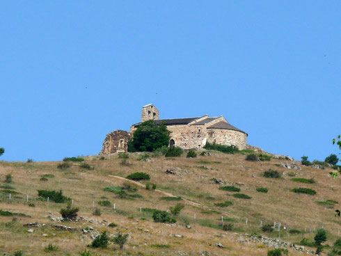
The essential from Dorres!!
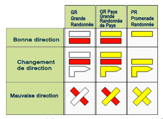
The hike is signposted from the village square.
Follow the GR Pays du Tour du Carlit (Cami Sant Marc) markers towards the west.
At the exit of the village, pass in front of the Mageta oratory.
At the crossroads, continue straight on along the shaded stone path, following the stream.
At Col de Juell, 2 variants:
1/ take the path on the left, marked in yellow, towards the south-east, towards the ridge. On the way up, very beautiful view of the hamlets of Brangoli, Fanès and Bena.
On the ridge, head south towards the chapel, passing the covered spring of Sant Pelegri.
2/ Follow the path near the water pipe, under the pine forest. Leaving the forest, go up to the right along the yellow marked path towards the chapel.
There, the view from Canigou to the Sierra del Cadi is quite exceptional. Also enjoy the coolness of the chapel in summer. (video)
Return: 3 variants
1/ via the vehicle track to the south.
2/ by the water pipe towards the Juell pass (variant 2 of the outward journey).
3/ by the yellow marked path which goes south-east, at the foot of the chapel, through meadows, with the passage of 2 barriers (remember to close them!) and the passage of the stream by the megalithic bridge > return towards the oratory of Mageta.
To discover the description and the site in video, thank you P.O. Express!
and a 360° view
DORRES > HAMEAU DE BRANGOLY
Distance : 13 km
Durée : ± 4h (AR)
Dénivelé : 350 m
Randonnée : Facile
Balisage : GR de Pays/PR
Référence IGN : 2249 0T/2250 ETR
Carte n° 8 Cerdagne 50.000e
La randonnée est balisée à partir de la place du village.
Suivre les balises GR Pays du Tour du Carlit (Cami Sant Marc) vers l'ouest.
A la sortie du village, passer devant le petit oratoire de Mageta.
Au croisement, continuer tout droit par le chemin empierré et ombragé, en longeant le ruisseau.
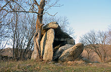
Au col de Juell, prendre vers le sud-ouest le sentier à droite, balisé en jaune. Traverser un chaos rocheux puis descendre dans une zone forestière vers les hameaux de Brangoli, Fanès et Bena.
A découvrir le Dolmen de Brangoli et l'église Saint-Fructueux et son joli cimetière.
ETANG DU LANOUX
Distance : 13 km
Durée : 5 à 6 h (AR)
Dénivelé : 520 m
Randonnée : Intermédiaire
Balisage : GR/GR de Pays
Référence IGN : 2249 0T
Carte n° 8 Cerdagne 50.000e
Au départ du parking de l'étang du Passet.
Préférer la montée par le chemin des Ingénieurs, taillé dans le roc, qui offre de belles perspectives sur la vallée.
Arrivée au lac, belle vue sur le Carlit, les Pics Pedros et la Coume d'Or.
Facile : Une variante familiale de l'étang du Passet à l'étang de Font-Vive... (environ 3h) vous permettra de voir peut-être quelques mouflons !

Plus d'itinéraires
Retrouvez les descriptifs des parcours sur PO Express - La Route des Catalans !
Share: